When it comes to aerial survey and mapping projects, accuracy is everything. Traditionally, survey teams relied on ground control points (GCPs)—physical markers placed across a site to provide reference coordinates. While effective, setting up GCPs is time-consuming, labor-intensive, and costly.
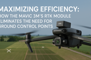
Enter the DJI Mavic 3 Multispectral (Mavic 3M) with its integrated RTK module. This technology delivers high-accuracy drone mapping without the hassle of GCPs, transforming how professionals in agriculture, construction, and environmental monitoring collect data.
What is RTK and Why Does It Matter?
RTK (Real-Time Kinematics) is a satellite navigation technique that enhances GPS positioning to centimeter-level accuracy. By connecting to a GNSS base station or a network, the Mavic 3M’s RTK module corrects positional errors in real time.
For surveyors, this means every image captured is geotagged with centimeter precision, eliminating the need to align maps with ground markers after the flight.
The Drawbacks of Ground Control Points (GCPs)
-
Time-Consuming Setup: Placing and surveying GCPs can take hours, especially on large or remote sites.
-
Increased Labor Costs: Teams often need extra personnel to set and measure points.
-
Environmental Limitations: GCPs are difficult to deploy in dense forests, wetlands, or hazardous environments.
With RTK-enabled drones like the Mavic 3M, these challenges disappear.
How the Mavic 3M’s RTK Improves Efficiency
-
Faster Project Completion
Without GCP setup, flight planning and execution become streamlined. Teams can start missions immediately, reducing total project time by up to 70%. -
Lower Operational Costs
Cutting down on manpower, travel, and equipment for GCP placement translates directly into savings. -
High-Precision Mapping
The Mavic 3M consistently delivers centimeter-level accuracy, suitable for applications like aerial survey, crop analysis, and infrastructure inspections. -
Repeatable Data Collection
RTK ensures consistent accuracy across missions, making it easy to monitor changes over time without re-establishing ground references.
Real-World Applications
-
Agriculture: Generate variable-rate application maps without field markers, saving time during the growing season.
-
Construction: Capture precise topographic surveys and progress reports quickly and cost-effectively.
-
Environmental Monitoring: Map wetlands, forests, or disaster zones without disturbing sensitive areas by placing GCPs.
The Bottom Line
The Mavic 3M’s RTK module redefines drone mapping efficiency. By eliminating the need for GCPs, it empowers surveyors and agronomists to achieve high-accuracy results faster, safer, and at lower cost. For professionals seeking to maximize efficiency in aerial surveys, this is a game-changer.
#SpeedyDrone #DJI #Mavic3M #DroneRTK #HighAccuracyDroneMapping #AerialSurvey #GroundControlPoints


