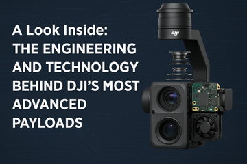

📌 Introduction: What Are DJI Enterprise Payloads?
Enterprise drones are only as powerful as the payloads they carry. A drone payload is any equipment mounted to a drone that extends its functionality — cameras, sensors, or tools that help capture data, build 3D models, inspect infrastructure, or support public safety operations.
DJI leads the industry with its Zenmuse payload series, designed to give professionals unparalleled precision, flexibility, and performance.
🔑 Why Payloads Matter for Enterprise Operations
-
Versatility: Swap payloads to switch between mapping, inspection, or rescue missions.
-
Accuracy: Payloads like the Zenmuse P1 and L2 deliver survey-grade precision.
-
Efficiency: Reduce time and cost compared to traditional ground methods.
-
Safety: Inspect dangerous or hard-to-reach assets without putting workers at risk.
🛠 DJI’s Zenmuse Payload Lineup
Here’s an overview of the key DJI Enterprise payloads in 2025:
🔹 Zenmuse V1
-
Regular price: $1,279.00
-
Entry-level enterprise payload ideal for operators who want to expand beyond basic imaging.
-
Designed for reliability and affordability while still delivering DJI-quality imaging performance.
-
Best for: Training, general inspection, and operators starting in enterprise drone work.
🔹 Zenmuse S1
-
Regular price: $1,829.00
-
A versatile, mid-tier sensor bridging the gap between affordability and advanced functionality.
-
Offers stronger performance than the V1 with improved optics and stability.
-
Best for: Utility inspections, infrastructure monitoring, and enterprise teams scaling operations.
🔹 Zenmuse P1 – Photogrammetry Powerhouse
-
Regular price: $9,099.00
-
DJI’s flagship full-frame photogrammetry camera, delivering survey-grade results.
-
45MP full-frame sensor for ultra-high-resolution imagery.
-
Supports Smart Oblique Capture for efficient mapping missions.
-
Integrated with RTK for centimeter-level accuracy.
-
Best for: Land surveying, construction planning, GIS, and urban 3D modeling.
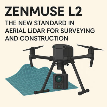
🔹 Zenmuse L2 – LiDAR + RGB for Next-Gen Mapping
-
Regular price: $18,099.00
-
DJI’s most advanced LiDAR payload with a built-in RGB camera.
-
Captures dense, high-accuracy point clouds for 3D mapping.
-
Built-in IMU for precision scanning with reduced noise.
-
Long-range detection for large-scale projects.
-
Best for: Forestry, mining, powerline inspection, and topographic surveying.
| Payload | Regular Price (CAD) | Highlight & Best Use Cases |
|---|---|---|
| Zenmuse V1 | $1,279 | Reliable, entry-level imaging for training or general inspection. |
| Zenmuse S1 | $1,829 | Mid-tier optics for utility and infrastructure monitoring. |
| Zenmuse P1 | $9,099 | High-res 45 MP full-frame photogrammetry—ideal for mapping, surveying, urban modeling. |
| Zenmuse L2 | $18,099 | Combined LiDAR + RGB for fast, millimeter-accurate 3D point-cloud mapping—perfect for forestry, mining, topography. |
🏭 Who Uses DJI Payloads?
-
Surveyors & Engineers → P1 & L2 for accurate mapping and 3D modeling.
-
Public Safety Teams → H20N or XT2 for search-and-rescue, fire response, and law enforcement.
-
Utility Inspectors → S1, Z30, or H20T for infrastructure and energy sector inspections.
-
Agriculture Professionals → L2 for precision terrain modeling and crop planning.
📊 Choosing the Right Payload for Your Mission
-
Need survey-grade mapping? → Zenmuse P1 or L2.
-
Need reliable inspection tools? → Zenmuse V1 or S1.
-
Need advanced 3D LiDAR scanning? → Zenmuse L2.
-
Need multi-sensor versatility? → Consider H20N or H20T.
🎯 Final Thoughts
DJI’s Zenmuse payload lineup gives professionals the tools to do more with their drones. From the affordable and versatile V1, to the workhorse S1, to the survey-grade P1, and the LiDAR-powered L2, there’s a payload for every industry and mission.
These payloads turn enterprise drones into indispensable tools for surveying, public safety, agriculture, utilities, and construction. If you’re investing in drone technology, choosing the right payload is just as important as choosing the drone itself.
#DJIEnterprise #DJIPayloads #ZenmuseV1 #ZenmuseS1 #ZenmuseP1 #ZenmuseL2 #DroneSurveying #DroneMapping #DroneInspection #EnterpriseDrones