
📌 Introduction: Two Paths to Surveying Excellence
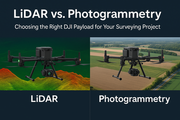
In the world of drone surveying and mapping, two technologies dominate the conversation: LiDAR and photogrammetry. Both methods allow professionals to create accurate maps and 3D models, but they work differently and shine in different conditions.
DJI offers specialized payloads for each:
-
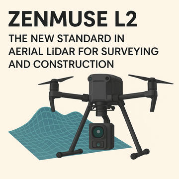
Zenmuse L2 → DJI’s next-generation LiDAR sensor with integrated RGB camera.
-
Zenmuse P1 → A full-frame photogrammetry powerhouse for high-resolution mapping.
So, which is right for your project? Let’s compare.
🌲 What is LiDAR and When to Use It?
LiDAR (Light Detection and Ranging) uses laser pulses to measure distances and generate dense, precise 3D point clouds.
🔹 Zenmuse L2 Highlights
-
Price: $18,099.00
-
Captures millimeter-accurate 3D data in real time.
-
Works through dense vegetation and complex terrain.
-
Includes integrated IMU and RGB camera for colorized point clouds.
-
Long-range detection, making it ideal for large areas.
✅ Best Use Cases for LiDAR
-
Forestry analysis and canopy penetration
-
Powerline inspection and corridor mapping
-
Topographic surveying in rough or vegetated terrain
-
Mining and quarry modeling
🏙️ What is Photogrammetry and When to Use It?
Photogrammetry uses overlapping photos and GPS data to generate detailed 2D maps and 3D models.
🔹 Zenmuse P1 Highlights
-
Price: $9,099.00
-
45MP full-frame sensor for ultra-sharp imagery.
-
Smart Oblique Capture improves efficiency by automating angled shots.
-
Integrated with RTK for centimeter-level accuracy.
-
Ideal for producing high-resolution orthomosaics.
✅ Best Use Cases for Photogrammetry
-
Land surveying for construction and urban planning
-
3D modeling of buildings and infrastructure
-
GIS mapping projects
-
Creating orthophotos and textured 3D meshes
⚖️ LiDAR vs. Photogrammetry: Key Differences
| Feature | LiDAR (Zenmuse L2) | Photogrammetry (Zenmuse P1) |
|---|---|---|
| Accuracy | Millimeter-level, works in vegetation | Centimeter-level, excellent in open terrain |
| Data Output | Dense 3D point cloud + colorized imagery | High-resolution 2D maps and 3D textured models |
| Environment | Best for forests, powerlines, rugged terrain | Best for urban areas, construction, clear landscapes |
| Processing Time | Faster results from LiDAR data | Photogrammetry requires heavy image processing |
| Cost | Higher ($18,099) | Lower ($9,099) |
🎯 Which Payload Should You Choose?
-
Choose LiDAR (L2) if your project involves dense vegetation, powerlines, or uneven terrain where photogrammetry struggles.
-
Choose Photogrammetry (P1) if you need high-resolution imagery, 3D textured models, or cost-effective mapping in open areas.
For many organizations, the best solution is often a hybrid workflow, where photogrammetry provides detailed visuals and LiDAR provides terrain-accurate point clouds.
🏆 Final Thoughts
When it comes to surveying with DJI drones, both LiDAR and photogrammetry have their place. The Zenmuse L2 delivers unparalleled accuracy and vegetation penetration, while the Zenmuse P1 offers sharp, high-resolution imagery at a more accessible price point.
At SpeedyDrone Canada, we help professionals across surveying, construction, and public safety choose the right DJI Enterprise payload to maximize results.
#SpeedyDroneCanada #DJIEnterprise #DJIPayloads #ZenmuseL2 #ZenmuseP1 #DroneSurveying #LiDARMapping #Photogrammetry #EnterpriseDrones #3DMapping