
When mapping with drones, accuracy matters. Traditionally, surveyors relied on Ground Control Points (GCPs)—markers placed and measured across a site to align aerial images. This method works, but it’s slow and labor-intensive.
The DJI Mavic 3M with RTK module changes the game. Instead of spending hours setting up GCPs, RTK delivers centimeter-level accuracy in real time. The result? Faster surveys, lower costs, and reliable high-precision maps.
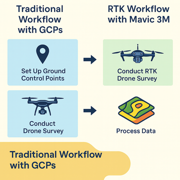
Traditional Workflow with GCPs
-
Set up ground control points across the survey area.
-
Fly the drone to capture images.
-
Process the images, aligning everything to the GCPs.
This process takes significant time and manpower—especially for large or remote projects.
RTK Workflow with Mavic 3M
-
Connect the RTK module.
-
Fly the drone and capture RTK-corrected images.
-
Process the data directly into accurate maps and models.
With RTK, there’s no need to place markers on the ground. Every image is geotagged with centimeter accuracy, ready for analysis.
The Benefits of RTK
-
Time Savings: Skip GCP setup and finish surveys faster.
-
Cost Reduction: Fewer staff hours and less equipment needed.
-
High Precision: Reliable centimeter-level accuracy for agriculture, construction, and environmental projects.
-
Efficiency at Scale: Perfect for repeat surveys and large areas where GCPs aren’t practical.
#SpeedyDrone #DJI #Mavic3M #DroneRTK #AerialSurvey #HighAccuracyMapping