Introduction
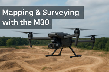
In industries like construction, infrastructure, and environmental monitoring, mapping and surveying play a vital role. While dedicated surveying drones such as the DJI Phantom 4 RTK, Mavic 3 Enterprise (M3E), or Matrice 300 RTK with P1 payload deliver the highest precision, the DJI Matrice 30 (M30) offers another advantage: speed and efficiency for quick 2D mapping and site overviews.
Quick 2D Mapping with the M30
The M30 series, equipped with its integrated wide-angle and zoom cameras, can generate basic 2D orthomosaic maps using DJI Pilot 2 or third-party software.
-
Fast Deployment: Lightweight and foldable, ready to fly within minutes.
-
Rapid Site Overviews: Capture aerial maps of construction sites, disaster zones, or inspection areas.
-
Cost-Effective: Reduces the need for external surveying teams for small-scale, time-sensitive projects.
Limitations in Precision Mapping
It’s important to note the M30 is not built for centimeter-level accuracy.
-
No RTK/PPK for photogrammetry (compared to M3E or M300 RTK setups).
-
Lower mapping accuracy—suitable for general site visualization, not survey-grade deliverables.
-
Payload Fixed System: Unlike the M300 RTK, it cannot carry photogrammetry-optimized payloads like the Zenmuse P1.
When to Use the M30 for Mapping
-
Disaster Response: Quickly generate situational maps after floods, fires, or earthquakes.
-
Construction Monitoring: Fast overviews of project progress without waiting for survey crews.
-
Utility & Infrastructure: Basic mapping for inspection planning or right-of-way visualization.
-
Security & Public Safety: Creating rapid area maps for event monitoring or incident response.
Comparison: M30 vs. Dedicated Surveying Drones
| Feature | DJI Matrice 30 | DJI Mavic 3 Enterprise (M3E) | DJI Matrice 300 RTK + P1 |
|---|---|---|---|
| Portability | High (foldable, compact) | Very high (smallest form) | Low (large platform) |
| Mapping Accuracy | Low–Moderate (good for overviews) | High (RTK support) | Very High (survey-grade photogrammetry) |
| Payload | Fixed (integrated wide/zoom/thermal in M30T) | Fixed (survey-optimized wide) | Modular (P1 camera for mapping, L1 LiDAR, etc.) |
| Best Use Case | Quick 2D maps & situational awareness | Precision mapping for small/medium projects | Professional-grade surveys & large-scale mapping |
Conclusion
The DJI Matrice 30 is not a replacement for dedicated surveying drones but a powerful complement. For teams that need rapid deployment, quick 2D mapping, and situational overviews, the M30 delivers unmatched speed and convenience. For survey-grade accuracy, the Mavic 3 Enterprise or M300 RTK with specialized payloads remain the gold standard.
By combining the M30’s agility with dedicated mapping drones, organizations can achieve a balanced workflow that prioritizes both speed and precision.
#DJIMatrice30 #MappingDrones #SurveyingDrones #DJIEnterprise #DroneMapping #ConstructionTech #AerialMapping #PublicSafetyDrones #DroneSurveying #M30Series


