
The DJI M350 RTK is more than a drone—it’s a modular inspection powerhouse. Its strength lies in payload versatility, allowing operators to swap between thermal imaging, LiDAR, and photogrammetry depending on the mission. This adaptability eliminates the need for multiple aircraft while maximizing ROI and operational efficiency across industries like energy, surveying, construction, and public safety.
Why Payload Flexibility Matters
Unlike consumer drones, enterprise platforms must adapt to many specialized tasks. The M350 RTK’s multi-gimbal support means operators can mount different payloads for different missions—without compromising precision or performance.
With payloads like the Zenmuse H20/H20T, Zenmuse L1, and Zenmuse P1, the M350 RTK provides a complete inspection toolkit.
Side-by-Side Payload Comparison
Here’s how DJI’s top payloads for the M350 RTK stack up:
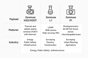
DJI M350 RTK Payload Comparison
| Payload | Key Features | Primary Function | Industry Use Cases |
|---|---|---|---|
| Zenmuse H20/H20T | 20 MP zoom, 12 MP wide, laser rangefinder, thermal (H20T) | Multi-sensor inspection (visual + thermal) | Energy, Utilities, Public Safety, Infrastructure |
| Zenmuse L1 | LiDAR module, RGB camera, high-accuracy IMU | Real-time 3D LiDAR mapping & point clouds | Surveying, Forestry, Construction |
| Zenmuse P1 | 45 MP full-frame sensor, interchangeable lenses, Smart Oblique Capture | High-resolution photogrammetry & mapping | Surveying, Urban Planning, Agriculture |
Zenmuse H20/H20T: Multi-Sensor Versatility
The H20 series combines optical zoom, wide-angle, laser rangefinding, and thermal imaging (H20T). It’s the go-to for all-in-one inspection missions.
Applications:
-
Detect faults in power grids before they escalate.
-
Locate missing persons with thermal search-and-rescue.
-
Inspect bridges and pipelines without risky manual climbs.
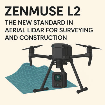
Zenmuse L1: LiDAR Precision in 3D
The L1 payload brings survey-grade LiDAR mapping to the M350 RTK. With its integrated RGB camera and high-accuracy IMU, it produces dense, colorized point clouds.
Applications:
-
Generate 3D terrain maps for surveying.
-
Track construction progress with real-time models.
-
Conduct forest biomass and canopy assessments.
Zenmuse P1: Photogrammetry at Scale
The P1 payload is DJI’s most advanced mapping solution. Its 45 MP full-frame sensor and interchangeable lenses provide unmatched detail.
Applications:
-
Capture orthomosaics for city planning.
-
Support agriculture with crop analysis and land monitoring.
-
Deliver fast, accurate survey outputs with reduced flight time.
Final Thoughts: One Drone, Infinite Possibilities
The M350 RTK is more than an aircraft—it’s an adaptable inspection ecosystem. With payloads like the H20 series, L1, and P1, it gives professionals the freedom to take on diverse missions with one reliable platform.
For industries that demand efficiency, precision, and flexibility, the DJI M350 RTK is the ultimate enterprise solution.
#DJIM350RTK #ZenmuseH20 #ZenmuseL1 #ZenmuseP1 #DJIEnterprise #DronePayloads #IndustrialInspections #LiDAR #Photogrammetry #ThermalImaging