Introduction
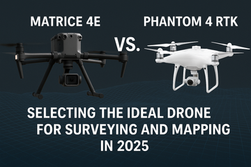
Choosing the right drone for surveying and mapping is all about balancing precision, coverage, and workflow scalability. The DJI Matrice 4E and Phantom 4 RTK both serve geospatial professionals—but they do so in markedly different ways. Let’s unpack how these two models stack up in 2025’s demanding mapping environments.
Core Feature Comparison
1. Imaging & Shutter Mechanics
-
Matrice 4E: Equipped with a 20 MP 4/3″ CMOS wide-angle camera featuring a mechanical shutter and variable aperture—ensuring distortion-free, high-quality imagery. It supports 0.5-second interval shooting, with advanced modes like 5‑directional oblique and Smart 3D Capture for more accurate modeling and faster workflows. DJI+14Heliguy™+14DJI Matrice Drone Forum+14DSLRPros
-
Phantom 4 RTK: Sports a high-precision camera and RTK positioning, but lacks mechanical shutter advantages, making it slightly less ideal for rapid, high-accuracy 3D capture. Wikipedia
2. Flight Time & Mission Efficiency
-
Matrice 4E: Offers up to 49 minutes of flight time—significantly longer than predecessors. This enables broader coverage and fewer interruptions. YouTube+11Dronefly+11DSLRPros+11
-
Phantom 4 RTK: Offers around 30 minutes of flight—adequate for smaller jobs but requiring more frequent battery changes for large surveying tasks. YouTube+5DJI+5DJI Matrice Drone Forum+5
3. Smart Mapping Capabilities
-
Matrice 4E shines with DJI’s Smart 3D Capture, dynamically adjusting flight paths to capture complex structures with precision—ideal for urban planning, infrastructure, or heritage models. YouTube+7Heliguy™+7Reddit+7
-
Phantom 4 RTK remains a solid performer for standard mapping, though its lack of dynamic mission tools puts it at a workflow disadvantage when modeling vertical or highly detailed structures.
4. Field Experience & Efficiency
According to a UAV mapping user:
“A survey that took 2 hours with a Phantom 4 Advanced would take roughly 45 minutes with the M4E, thanks to Smart Oblique.”
“Mapping efficiency at least doubled… much faster in the air… many more flight planning options (Smart oblique, terrain follow, Smart 3D…).” Reddit+2DJI Matrice Drone Forum+2
Side-by-Side Snapshot
| Feature / Attribute | Matrice 4E | Phantom 4 RTK |
|---|---|---|
| Shutter Type | Mechanical + Electronic | Electronic only |
| Smart Mission Tools | Smart 3D Capture, Oblique Modes | Manual mission planning |
| Interval Shooting | 0.5 seconds | Standard intervals |
| Flight Time | Up to 49 minutes | Approx. 30 minutes |
| Mapping Efficiency | High — dynamic routes and structures | Good — linear coverage |
| Field Feedback | >2× faster, highly accurate mapping | Reliable, but less flexible in complex zones |
Final Recommendation
-
Choose the Matrice 4E if your work involves large-scale surveys, time-critical mapping, or complex 3D modeling—its mechanical shutter, long flight time, and smart capture features offer undeniable efficiency gains.
-
Still a strong choice for smaller-scale precision tasks or those comfortable with manual mission planning? The Phantom 4 RTK remains a compact and accurate performer—but with less workflow flexibility.
#Matrice4E #Phantom4RTK #SurveyingDrones #MappingTech #3DModeling #DroneSurveying #Geospatial #Smart3DCapture #DroneComparison #AerialMapping


